Welcome to
East Coventry
Welcome to
East Coventry
Our vision for East Coventry is to transform a 122 acre area of underutilized industrial land into a high-quality residential neighbourhood that feels connected to the existing community of Coventry Hills. The project will build on current infrastructure to bring new housing options and welcomed amenities – rather than warehouses and expansive parking lots.


About East Coventry
Developed by WestCreek Developments, East Coventry embraces Calgary’s goals for sustainable and complete communities. To begin the transition from its current industrial land use to residential, a Land Use Amendment (LUA) and Outline Plan (OP) are required. Amendments to the Revised Stoney Industrial Area Structure Plan (ASP), the Calgary North Phase 1 ASP, and the Municipal Development Plan (MDP) are also required to support the transition. The planning amendment applications are led by B&A Studios, an urban planning, design and engagement firm. The development proposes to create a road connection from East Coventry to join the existing community of Coventry Hills. The connection benefits Coventry Hills residents by providing new accessibility to and from Deerfoot Trail, City Centre and the East Industrial area, as well as quick convenience to East Coventry’s future commercial amenities.
Protecting Nose Creek
The outline plan includes approximately 47 acres of environmental reserve to protect the creek corridor and adjacent slopes. It also proposes a mix of ground-oriented and multi-residential uses, a small commercial site, and more than 6 acres of open space along the escarpment to further safeguard the valley. A Biophysical Impact Assessment (BIA) has been completed to inform the plan and was included in the application to the City.
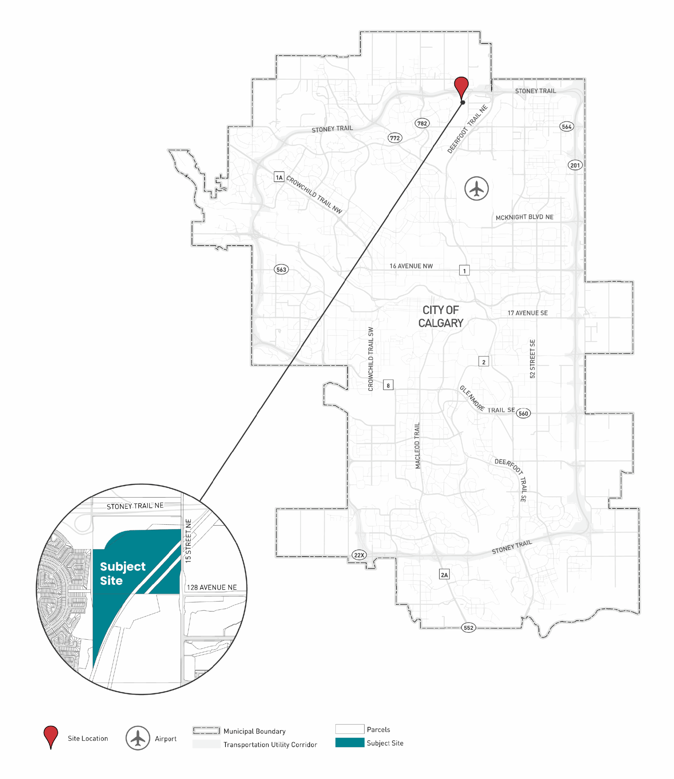
The Location
The undeveloped subject lands are bounded by Stoney Trail NE to the north, industrial lands and 15 Street to the east, and Nose Creek to the south, and Coventry Hills to west. The future development of East Coventry is ideally located to nearby amenities, transit services, employment and within 5 kilometres of the Calgary International Airport and major shopping conveniences at CrossIron Mills.
Project Information
The subject lands are currently zoned for Special Purpose – Future Urban Development (S-FUD) which is a land use district that is applied to lands that are awaiting urban development and utility servicing. The proposed application will amend the land use to Residential – Low Density Mixed Housing (R-G) (R-Gm) Districts to allow for a low density neighbourhood over most of the plan area. 1.6 acres of Multi-Residential Medium Profile (M-2) District and 3.0 acres of Community Commercial 2 (C-C2) District are also proposed in the north portion of the neighbourhood with parks and open space throughout the neighbourhood to provide amenity space for future and existing residents.
Amendments to the Revised Stoney Industrial ASP, the Calgary North Phase 1 ASP, and the Municipal Development Plan are required to support the proposed development. Area Structure Plans (ASP) and Land Use Bylaws are policy documents that inform the local development and the planning process. View the FAQ section for more information.

Timeline
The following timeline reflects the land planning process and the anticipated dates are subject to change.
Frequently Asked Questions
Stay Connected
Use the form below to register for email updates about upcoming engagement opportunities and project milestones. Questions? Reach out to Leah Thomson, Engagement Specialist at lthomson@bastudios.ca